 AVYCAST
Craigieburn Range — Boletín de aludes
El peligro de aludes en Craigieburn Range (Nueva Zelanda) es 3 — Notable, válido para lunes, 28 de septiembre de 2026. Publicado por New Zealand Avalanche Advisory.
La nieve en primavera generalmente se une bien, pero el sol de septiembre aumentará rápidamente el riesgo de placa de tormenta si hace su aparición por la tarde.
Peligro por cota
Problemas de aludes activos
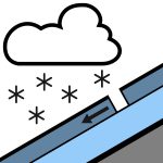

Reporte de nil en las últimas 48 horas. Domingo: Se espera lluvia en la mañana, posiblemente fuerte y cayendo como nieve por encima de los 500 m. La lluvia disminuirá en la tarde y despejará en la noche. Los vientos del oeste girarán al suroeste en la mañana. Nivel de congelación 800 m. Lunes: Chubascos aislados, con períodos de mayor nubosidad. Vientos fuertes del oeste al suroeste. Nivel de congelación 1000 m, aumentando a 1400 m en la mañana. Se recomienda el uso de piolet y crampones, ya que la superficie de nieve puede estar dura, especialmente en la mañana, y luego ablandarse durante el día. Los crampones para esquí serán útiles si se aventura en esquís o snowboard.
La cobertura de nieve en toda la zona de pronóstico es sumamente variable. Hasta 150 cm en algunas áreas, hasta rocas cubiertas de escarcha en otras. El manto nivoso ahora es isotérmico en todas las áreas por debajo de los 1800 m. El clima cálido de las últimas semanas ha creado un manto nivoso similar a la primavera. Se ha producido un buen ciclo de fusión y congelación, lo que favorece el esquí en cornisa. Cayó 10 cm de nieve seca y ligera durante la noche y el 23/09, con otros 8 cm el 24/09.
Fuente: New Zealand Avalanche Advisory · Ver boletín original
Traducido (EN)
Preguntas frecuentes
¿Qué significa el nivel de peligro de aludes 3 (Notable)?
Condiciones peligrosas — una sola persona puede desencadenar aludes en muchas laderas empinadas; es esencial elegir el itinerario con prudencia.
¿Con qué frecuencia se actualiza el boletín de Craigieburn Range?
Avycast se actualiza cada hora; New Zealand Avalanche Advisory vuelve a publicar el boletín normalmente una vez al día durante la temporada.
¿Quién publica el boletín de aludes de Craigieburn Range?
New Zealand Avalanche Advisory — el servicio oficial de alerta. Avycast lo agrega y lo traduce; consulta siempre el boletín original.
Regiones cercanas
- Arthur's Pass · 29 km
- Mt Hutt · 31 km
- Two Thumbs · 101 km
- Aoraki/Mt Cook · 128 km
- Nelson Lakes · 162 km
- Ohau · 188 km