 AVYCAST
Arthur's Pass — Boletín de aludes
El peligro de aludes en Arthur's Pass (Nueva Zelanda) es 3 — Notable, válido para martes, 29 de septiembre de 2026. Publicado por New Zealand Avalanche Advisory.
El pronóstico de nieve para mañana aumentará el riesgo de placa de tormenta a medida que avance el día. Se pronostica que el nivel de congelación disminuirá; por lo tanto, se espera que todas las altitudes tengan un riesgo creciente. Los totales en la Cuenca de Tempe serían superiores a 25 cm en las próximas 24 horas. Se requieren habilidades de evaluación precisas para un riesgo cambiante con cualquier viaje fuera de pista mañana.
Peligro por cota
Problemas de aludes activos
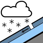

No se reporta nada en las últimas 24 horas. ¡Por favor, continúe enviando estas observaciones públicas! Son un recurso excelente para los usuarios de la montaña y muy útiles para nosotros en la predicción. Por lo tanto, informe cualquier alud que vea o encuentre en la sección de observaciones públicas del sitio web de NZAA. La lluvia, a veces intensa y cayendo como nieve por encima de los 800 metros, disminuirá a chaparrones ocasionales por la tarde. Vientos del noroeste a 40 km/h cambiando a del sur a 30 km/h a media mañana. El nivel de congelación está en 1000 metros y subirá a 1300 metros por la tarde. La lluvia suavizará el manto nivoso por la mañana. Un ciclo de fusión/congelación ha estado ocurriendo durante la última semana. Es recomendable usar crampones y piolet.
El manto nivoso está generalmente bien consolidado, con lluvia en las cumbres a principios de semana. Las recientes nevadas han aportado hasta 15 cm en las altitudes más altas por encima de 2100 m, pero esto varía según la ubicación, con cada valle teniendo diferentes totales. La nieve nueva en las altitudes más altas está bien consolidada.
Fuente: New Zealand Avalanche Advisory · Ver boletín original
Traducido (EN)
Preguntas frecuentes
¿Qué significa el nivel de peligro de aludes 3 (Notable)?
Condiciones peligrosas — una sola persona puede desencadenar aludes en muchas laderas empinadas; es esencial elegir el itinerario con prudencia.
¿Con qué frecuencia se actualiza el boletín de Arthur's Pass?
Avycast se actualiza cada hora; New Zealand Avalanche Advisory vuelve a publicar el boletín normalmente una vez al día durante la temporada.
¿Quién publica el boletín de aludes de Arthur's Pass?
New Zealand Avalanche Advisory — el servicio oficial de alerta. Avycast lo agrega y lo traduce; consulta siempre el boletín original.
Regiones cercanas
- Craigieburn Range · 29 km
- Mt Hutt · 59 km
- Two Thumbs · 118 km
- Aoraki/Mt Cook · 136 km
- Nelson Lakes · 142 km
- Ohau · 203 km