 AVYCAST
Aoraki/Mt Cook — Bollettino valanghe
Il pericolo valanghe in Aoraki/Mt Cook (Nuova Zelanda) è 3 — Marcato, valido per domenica 27 settembre 2026. Pubblicato da New Zealand Avalanche Advisory.
Un importante fronte di tempesta sta attraversando la regione domenica mattina. In primavera, queste tempeste sono seguite da un rapido riscaldamento, che può aumentare la probabilità di valanghe naturali. Evitare terreni soggetti a lastra da vento e fare attenzione a valanghe di slittamento di neve umida e sciolta che si staccano da pendii ripidi e soleggiati se il sole compare nel pomeriggio.
Pericolo per quota
Problemi valanghivi attivi
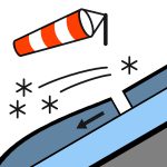

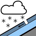
Non sono state osservate nuove valanghe nelle ultime 48 ore. Neve, possibilmente abbondante, in diminuzione nel pomeriggio e con schiarite entro sera. Vento a 1000 metri: da nord 50 km/h, in aumento a burrasca 70 km/h per un certo tempo prima dell’alba, poi ruota a sud-ovest 40 km/h in mattinata. Vento a 2000 metri: burrasca da nord-ovest 70 km/h, che si attenua a sud-ovest 50 km/h prima dell’alba. Vento a 3000 metri: burrasca severa da nord-ovest 90 km/h, che si attenua a burrasca da sud-ovest 70 km/h in mattinata. Livello di neve: 1800 metri, in rapido abbassamento a 800 metri prima dell’alba, risalendo a 1100 metri in serata. Sono presenti croste lisce su tutta la regione prevista sotto circa 2400m. Nonostante la neve fresca di domenica, venti forti o burrasca potrebbero esporre queste croste. Si raccomandano ramponi e piccozza.
Circa 40cm di neve fresca sono caduti vicino al Divide tra il 24 e il 25, sopra circa 1800m, con accumuli di neve che diminuiscono a quote più basse e a sud della catena del Liebig. Questa neve è stata ridistribuita dai venti di burrasca da ovest sabato, formando accumuli più profondi e lastra da vento su pendii esposti a est, e si trova su una crosta di pioggia di 5cm del 21 settembre fino a 2400m. Gli stessi venti di burrasca da ovest avranno ripulito i pendii esposti a ovest fino a questa crosta. Temperature più calde, effetto serra e fino a 10mm di precipitazione sabato hanno coperto il manto nevoso con una sottile crosta di fusione e congelamento fino a circa 2300m. Il manto inferiore è generalmente ben consolidato.
Fonte: New Zealand Avalanche Advisory · Vedi bollettino originale
Tradotto (EN)
Domande frequenti
Che cosa significa il grado di pericolo valanghe 3 (Marcato)?
Condizioni critiche — una singola persona può staccare valanghe su molti pendii ripidi; è indispensabile una scelta prudente dell'itinerario.
Con quale frequenza viene aggiornato il bollettino di Aoraki/Mt Cook?
Avycast aggiorna ogni ora; New Zealand Avalanche Advisory ripubblica il bollettino di solito una volta al giorno durante la stagione.
Chi pubblica il bollettino valanghe di Aoraki/Mt Cook?
New Zealand Avalanche Advisory — il servizio valanghe ufficiale. Avycast lo aggrega e lo traduce; consulta sempre il bollettino originale.
Regioni vicine
- Two Thumbs · 45 km
- Ohau · 77 km
- Mt Hutt · 113 km
- Craigieburn Range · 128 km
- Arthur's Pass · 136 km
- Aspiring · 147 km