 AVYCAST
Arthur's Pass — Lawinenlagebericht
Die Lawinengefahr in Arthur's Pass (Neuseeland) ist 3 — Erheblich, gültig für Dienstag, 29. September 2026. Veröffentlicht von New Zealand Avalanche Advisory.
Die Schneeforcast für morgen wird im Verlauf des Tages die Gefahr durch Neuschneeansammlung erhöhen. Die Frostgrenze wird voraussichtlich sinken; daher ist mit zunehmender Gefahr auf allen Höhenlagen zu rechnen. Die Gesamtschneemenge im Tempe-Becken wird in den nächsten 24 Stunden über 25 cm liegen. Gute Einschätzungsfähigkeiten sind erforderlich, da sich die Gefahr bei jeder Bergtour morgen ändern kann.
Gefahr nach Höhenlage
Aktive Lawinenprobleme
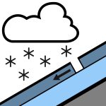

In den letzten 24 Stunden wurden keine Meldungen gemacht. Bitte senden Sie weiterhin diese öffentlichen Beobachtungen! Sie sind eine wertvolle Ressource für Bergsteiger und äußerst hilfreich für unsere Prognosen. Bitte melden Sie jegliche Lawinen, die Sie sehen oder bei denen Sie auf öffentliche Beobachtungen auf der NZAA-Website stoßen. Regen, zeitweise stark, fällt oberhalb von 800 Metern als Schnee, am Nachmittag auf einzelne Schauer abnehmend. Winde aus Nordwest mit 40 km/h, am Vormittag auf Süd umschwenkend mit 30 km/h. Die Frostgrenze liegt bei 1000 Metern und steigt am Nachmittag auf 1300 Meter. Der Regen wird die Schneedecke am Morgen erweichen. In der letzten Woche hat ein Schmelz-/Gefrierzyklus stattgefunden. Steigeisen und Eispickel sind empfehlenswert.
Die Schneedecke ist im Allgemeinen gut gesetzt, mit Regen an den Gipfeln zu Beginn der Woche. Kürzliche Schneefälle haben bis zu 15 cm an höheren Lagen über 2100 m gebracht, wobei die Mengen je nach Standort variieren, da jedes Tal unterschiedliche Mengen aufweist. Der Neuschnee in höheren Lagen ist gut gesetzt.
Quelle: New Zealand Avalanche Advisory · Original-Lagebericht ansehen
Übersetzt (EN)
Häufige Fragen
Was bedeutet Lawinengefahrenstufe 3 (Erheblich)?
Kritische Lawinensituation — eine einzelne Person kann an vielen Steilhängen Lawinen auslösen; vorsichtige Routenwahl ist unerlässlich.
Wie oft wird der Lagebericht für Arthur's Pass aktualisiert?
Avycast aktualisiert stündlich; New Zealand Avalanche Advisory veröffentlicht den Lagebericht in der Saison meist einmal täglich neu.
Wer veröffentlicht den Lawinenlagebericht für Arthur's Pass?
New Zealand Avalanche Advisory — der offizielle Lawinenwarndienst. Avycast bündelt und übersetzt ihn; prüfe immer den Originalbericht.
Regionen in der Nähe
- Craigieburn Range · 29 km
- Mt Hutt · 59 km
- Two Thumbs · 118 km
- Aoraki/Mt Cook · 136 km
- Nelson Lakes · 142 km
- Ohau · 203 km