 AVYCAST
Arthur's Pass — Bulletin d'avalanche
Le danger d'avalanche en Arthur's Pass (Nouvelle-Zélande) est 3 — Marqué, valable pour mardi 29 septembre 2026. Publié par New Zealand Avalanche Advisory.
La prévision de neige pour demain augmentera le risque de plaque à vent à mesure que la journée avance. Le niveau de gel devrait diminuer ; par conséquent, il faut s’attendre à une augmentation du risque à toutes les altitudes. Les totaux au bassin de Tempe dépasseraient 25 cm dans les prochaines 24 heures. Des compétences d’évaluation solides sont nécessaires pour gérer un risque en évolution lors de toute sortie en terrain non balisé demain.
Danger par altitude
Problèmes d'avalanches actifs
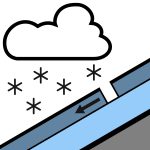

Rien de signalé au cours des dernières 24 heures. Veuillez continuer à transmettre ces observations publiques ! Elles constituent une ressource précieuse pour les utilisateurs de la montagne et sont très utiles pour nos prévisions. Donc, veuillez signaler toute avalanche que vous voyez ou rencontrez dans la section des observations publiques du site Web de la NZAA. La pluie, parfois forte, tombant sous forme de neige au-dessus de 800 mètres, s’atténuant en une ou deux averses dans l’après-midi. Vent nord-ouest à 40 km/h, changeant en vent du sud à 30 km/h en milieu de matinée. Le niveau de gel est à 1000 mètres, montant à 1300 mètres dans l’après-midi. La pluie ramollira le manteau neigeux le matin. Un cycle de fonte / regel s’est produit au cours de la dernière semaine. Il est conseillé d’utiliser des crampons et un piolet.
Le manteau neigeux est généralement bien stabilisé, avec de la pluie en hautes altitudes plus tôt dans la semaine. Les chutes de neige récentes ont apporté jusqu’à 15 cm à des altitudes supérieures à 2100 m, mais cela varie selon l’emplacement, chaque vallée ayant des totaux différents. La nouvelle neige en haute altitude est bien stabilisée.
Source: New Zealand Avalanche Advisory · Voir le bulletin d'origine
Traduit (EN)
Questions fréquentes
Que signifie le niveau de danger d'avalanche 3 (Marqué) ?
Conditions dangereuses — une seule personne peut déclencher des avalanches sur de nombreuses pentes raides ; la prudence dans le choix de l'itinéraire est essentielle.
À quelle fréquence le bulletin de Arthur's Pass est-il mis à jour ?
Avycast actualise toutes les heures ; New Zealand Avalanche Advisory republie le bulletin généralement une fois par jour pendant la saison.
Qui publie le bulletin d'avalanche de Arthur's Pass ?
New Zealand Avalanche Advisory — le service d'alerte officiel. Avycast l'agrège et le traduit ; consultez toujours le bulletin original.
Régions à proximité
- Craigieburn Range · 29 km
- Mt Hutt · 59 km
- Two Thumbs · 118 km
- Aoraki/Mt Cook · 136 km
- Nelson Lakes · 142 km
- Ohau · 203 km