 AVYCAST
Queenstown — Lawinenlagebericht
Die Lawinengefahr in Queenstown (Neuseeland) ist 3 — Erheblich, gültig für Sonntag, 27. September 2026. Veröffentlicht von New Zealand Avalanche Advisory.
Kürzlich gebildete Triebschneeschichten werden heute Morgen reaktiv sein. Vermeiden Sie Bereiche mit offensichtlicher Belastung und schlechten Auslaufmöglichkeiten. Expertenanalyse des Geländes und fundierte Entscheidungen sind für eine sichere Tour im Backcountry am Anfang erforderlich. Obwohl es kalt ist, sind lockere, nasse Lawinen möglich, wenn die Sonne erscheint.
Gefahr nach Höhenlage
Aktive Lawinenprobleme
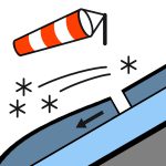

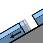
Gestern wurden keine Vorfälle gemeldet. Stürmischer NW-Wind, der sich am Morgen nach SW dreht. Der Schneefall lässt im Laufe des Tages allmählich nach. Kalte Temperaturen, mit der FAFL sinkend auf 700 m. Bereiche, in denen der Wind den Neuschnee entfernt hat, werden sehr glatt sein. Exponierte westseitige Hänge sind zu meiden.
10-20 cm Neuschnee in der Nacht auf tiefe Lagen. Wahrscheinliche Belastung bis zu 80 cm auf leeseitigen Hängen. Es wird eine vernünftige Verbindung zur warmen/warmen nassen alten Schneedecke in den meisten Gebieten erwartet. Dies fällt auf eine nasse obere Schneedecke in den meisten Gebieten. Bereiche, die dem Wind ausgesetzt sind und entblößt wurden, werden heute gefroren und eisig sein. Die mittlere und untere Schneedecke ist im Allgemeinen gut konsolidiert, aber dünne Bereiche werden an mittleren und unteren Lagen nass und unkonso-lidiert. Gleitschneespalten und Verformungen wurden an sonnigen Hängen in tieferen Lagen beobachtet.
Quelle: New Zealand Avalanche Advisory · Original-Lagebericht ansehen
Übersetzt (EN)
Häufige Fragen
Was bedeutet Lawinengefahrenstufe 3 (Erheblich)?
Kritische Lawinensituation — eine einzelne Person kann an vielen Steilhängen Lawinen auslösen; vorsichtige Routenwahl ist unerlässlich.
Wie oft wird der Lagebericht für Queenstown aktualisiert?
Avycast aktualisiert stündlich; New Zealand Avalanche Advisory veröffentlicht den Lagebericht in der Saison meist einmal täglich neu.
Wer veröffentlicht den Lawinenlagebericht für Queenstown?
New Zealand Avalanche Advisory — der offizielle Lawinenwarndienst. Avycast bündelt und übersetzt ihn; prüfe immer den Originalbericht.
Regionen in der Nähe
- Wanaka · 28 km
- Aspiring · 53 km
- Fiordland · 91 km
- Ohau · 101 km
- Aoraki/Mt Cook · 173 km
- Two Thumbs · 188 km