 AVYCAST
Queenstown — Boletín de aludes
El peligro de aludes en Queenstown (Nueva Zelanda) es 3 — Notable, válido para domingo, 27 de septiembre de 2026. Publicado por New Zealand Avalanche Advisory.
Las placas de viento recientemente formadas serán reactivas esta mañana. Evite áreas de carga evidente y de salidas de avalancha deficientes. Se necesitará un análisis experto del terreno y toma de decisiones para un viaje seguro en el interior de la montaña en las primeras horas. Aunque hace frío, serán posibles avalanchas de nieve húmeda y suelta si el sol hace acto de presencia.
Peligro por cota
Problemas de aludes activos
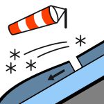

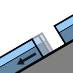
No se reportaron incidentes ayer. Vientos fuertes del NW en tendencia a SW por la mañana. La nieve se suaviza lentamente a lo largo del día. Temperaturas frías con la FAFL descendiendo a 700 m. Las áreas donde la placa de viento ha eliminado la nieve nueva serán muy resbaladizas. Las pendientes expuestas al oeste serán áreas a evitar.
10-20 cm de nieve nueva durante la noche en elevaciones bajas. Probable acumulación de hasta 80 cm en pendientes de lee. Se espera una unión razonable con la superficie vieja cálida y húmeda en la mayoría de las áreas. Esto se asienta sobre un manto nivoso superior húmedo en la mayoría de las áreas. Las áreas expuestas a los vientos y desprovistas de nieve estarán congeladas y heladas hoy. El manto nivoso medio e inferior está generalmente bien consolidado, pero las áreas delgadas se están volviendo húmedas y no consolidadas en elevaciones medias e inferiores. Se han observado grietas de alud de fondo y deformaciones en pendientes soleadas en elevaciones bajas.
Fuente: New Zealand Avalanche Advisory · Ver boletín original
Traducido (EN)
Preguntas frecuentes
¿Qué significa el nivel de peligro de aludes 3 (Notable)?
Condiciones peligrosas — una sola persona puede desencadenar aludes en muchas laderas empinadas; es esencial elegir el itinerario con prudencia.
¿Con qué frecuencia se actualiza el boletín de Queenstown?
Avycast se actualiza cada hora; New Zealand Avalanche Advisory vuelve a publicar el boletín normalmente una vez al día durante la temporada.
¿Quién publica el boletín de aludes de Queenstown?
New Zealand Avalanche Advisory — el servicio oficial de alerta. Avycast lo agrega y lo traduce; consulta siempre el boletín original.
Regiones cercanas
- Wanaka · 28 km
- Aspiring · 53 km
- Fiordland · 91 km
- Ohau · 101 km
- Aoraki/Mt Cook · 173 km
- Two Thumbs · 188 km