 AVYCAST
Wanaka — Lawinenlagebericht
Die Lawinengefahr in Wanaka (Neuseeland) ist 3 — Erheblich, gültig für Montag, 28. September 2026. Veröffentlicht von New Zealand Avalanche Advisory.
Übersetzung läuft — Anzeige in Originalsprache
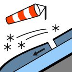
Snow to low levels and strong to gale South West winds are forecast. Wind Slab development is probable. Be on the lookout for blowing snow and stay clear of areas where it is accumulating.
Gefahr nach Höhenlage
Aktive Lawinenprobleme

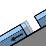
Observations have been hampered over the past 24 hours by storm activity. Wet slides (Loose Wet, Wet Slab and Glide) a few days ago. A skier accidentally triggered a size 1.5 Loose Wet slide on Friday (18/9) in the backcountry near Treble Cone. A cycle of natural wet slides (size 1 and 1.5) occurred on Thursday and Friday as the day warmed up. If you see evidence of avalanches in the back country please enter a Public Observation. Sunday - snow overnight Saturday down to 400m. Snow showers easing during the morning. North West winds turning South West and rising to gale force at upper elevations. Freezing level - 1700m falling rapidly to 800m before dawn. Spring conditions (melt/freeze) generally result in an elevated sliding hazard. Slick crusts and icy areas have been widespread especially, below about 1850m. Recommend carrying ski crampons and/or an ice axe and crampons.
A mixture of rain and snow over the past 24 hours (15mm in the Albert Burn). The underlying snow pack above about 1800m is mostly well consolidated. The snow pack is likely to be holding a significant amount of moisture below about 1800m. Prior to the most recent storm a typical Spring melt/freeze cycle was occurring.
Quelle: New Zealand Avalanche Advisory · Original-Lagebericht ansehen
Original (EN)
Häufige Fragen
Was bedeutet Lawinengefahrenstufe 3 (Erheblich)?
Kritische Lawinensituation — eine einzelne Person kann an vielen Steilhängen Lawinen auslösen; vorsichtige Routenwahl ist unerlässlich.
Wie oft wird der Lagebericht für Wanaka aktualisiert?
Avycast aktualisiert stündlich; New Zealand Avalanche Advisory veröffentlicht den Lagebericht in der Saison meist einmal täglich neu.
Wer veröffentlicht den Lawinenlagebericht für Wanaka?
New Zealand Avalanche Advisory — der offizielle Lawinenwarndienst. Avycast bündelt und übersetzt ihn; prüfe immer den Originalbericht.
Regionen in der Nähe
- Aspiring · 25 km
- Queenstown · 28 km
- Ohau · 90 km
- Fiordland · 98 km
- Aoraki/Mt Cook · 156 km
- Two Thumbs · 176 km